Demystifying GIS, the Cliff's Notes Version
We're going to cover a few things today:
- Demystifying GIS, the cliff's notes version
- A typical Delta case study
- How to request a map product for your project: save time, make friends, be excellent
There are a few common map-making scenarios at Delta:
1. You want some information displayed on a map. Example: Detroit demo permits
2. You have some geospatial data and you want to use it to answer a question. Example: Little Village brownfields
3. You want to use a map to get a better sense of a problem. Example: Prioritizing erosion vulnerability
4. You are preparing a publication and need something designed. Example: K6 binder cover
Before we get too far in the weeds, let's talk about what we mean by GIS.
"A geographic information system (GIS) is a computer system designed to capture, store, manipulate, analyze, manage, and present all types of spatial or geographical data." -
WikipediaThat's all well and good, but when most people talk about GIS, they are really talking about...
ArcMap is the quintessential desktop GIS. It's very powerful and most of us have interacted with in one way or another at some point, but it can be cumbersome, has some tricky proprietary formats and so on, so we use a whole suite of tools
Some folks here have gotten a crash course in
QGIS, an open-source desktop GIS that can do pretty much everything ArcMap can do and is free.
We also use a bunch of free or paid online services...
Google Maps, Google Earth, Google Fusion Tables, GeoCommons, BatchGeo, CartoDB, CrossLet, ESRI Business Analyst Online, ESRI ArcGIS Online, GeoJSON.io, etc, etc, etc...
So...
Based on the earlier GIS definition, all of these things qualify as GIS and each has a part in the way we collect, manipulate, analyze and present geospatial data.
Let's take a quick look under the hood.
We'll cover a couple of things really quickly, so don't worry if some of it still feels abstract. We don't have enough time to go really in depth, so I've tried to link to resources wherever possible. This is really just to give you a high-level glance at what's going on when we make maps here.
- Common data formats
- Geodesy
There are two main types of geodata you'll run into: vector and raster.
Vector geo data has three things: geometry, a location, and attribute information.
Like vector data, raster data contains location. But it stores its attribute information differently. Raster data stores its information in its pixels. This information can include height, slope, direction, color, and many others.
- Common data formats
- Geodesy
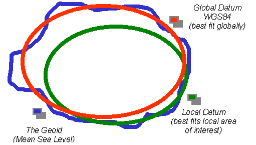
Geodesy (gee-Odyssey). A lot of folks who learn ArcMap miss out on the finer points (because ArcMap is smart and abstracts this bit away), but geodesy is what makes mapping work. Here's a real brief rundown
To recap...
You need to know the geoid or, to put another way, mathematical model of our "lumpy earth"
You need to know the datum, or coordinate system, that takes into account all of your reference earth's lumps
You need to define a projection, or method for transforming your data from a sphere to a plane.
Let's bring it all together by cracking open a vector file
DEMO
Okay, great. Let's talk more about that process with an example.
This is a fairly typical workflow we see across our projects and we'll use it to talk about how we typically get from idea to finished product and all of the steps along the way.
Example 1: Little Village
Concept:
- Use a bunch of readily available data to figure out where potential redevelopment sites are located, within Little Village's neighborhood boundaries.
- Once you've got your list of sites, use the geospatial data to help guide on-the-ground data collection
- Produce a large, illustrative map for a stakeholder meeting
Step 1, ID'ing sites: OMG addresses
Waddya gonna do with that spreadsheet full of addresses?
LITTLE VILLAGE BROWNFIELD DATA SHOW AND TELL
Geocoding is the process of turning addresses into lat/long coordinates.
This process is what allows us to put a bunch of points onto a map and view them. It relies on super complicated databases, usually maintained by private companies like ESRI or Google in order to function.
Step 2, ID'ing sites some more: D'oh! It turns out the city's address database doesn't align with the county's parcel boundaries.
We really needed to know the county PIN for each potential site in order to look up that site's assessor data, but there didn't seem to be a single dataset with both the addresses and the county PINs.
Enter geosprocessing!
Geoprocessing is what separates data analysis in excel from data analysis in a GIS.
Because your data is spatially enabled (this really just means that your data has lat/long coordinates associated with it), GIS software can perform some fancy analysis, such as...
Tell me whether this point (address) falls within a polygon (parcel) and, if it does, spit out a new dataset with that extra info tacked on at the end.
Step 3, ID'ing sites even more: Oh no. Our project boundary wasn't correctly defined.
This happens all the time. Once you get into a project, you realize you forgot something at the beginning.
In this case, our partner told us that the project fell across two zip codes. Turns out it was 3. That's okay.
At the end of this presentation, we'll talk about a couple of ways we can try to avoid these issues by asking some strategic questions at the outset.
Step 4, Helping out the data collectors
Sometimes you just can't beat on-the-ground observation, which meant sending a bunch of students out into the field. To help them find their way, I put together some printed maps.
Demo!
Step 5, producing a map for the stakeholder meeting
Another key element of the LV project is the stakeholder process. This is common with Delta projects.
For this type of work, we produce a big, easy-to-read map with some important elements displayed.
In this case, the map helped facilitate the discussion and get people thinking about how a bunch of potential redevelopment sites fit into the fabric of their neighborhood.
DEMO!
Some key elements to this process:
- How big is the map going to be? This will dictate how each map element gets scaled and placed in the designed product.
- Which information should be displayed?
- Do we already have that information or do we need to find it or create it? What format is it in and how much cleanup will need to be performed?
- Who is going to print the map for us and what format do they require?
- Who needs to review the product before it is printed? When are they expecting to receive a draft and how long will they need to respond?
WHEW! Thanks for hanging in there.
To recap the Little Village case study...
We geocoded a lot of different datasets and brought them together
We used geoprocessing to figure out where addresses (points) fell withing parcels (polygons) and generated a new dataset with both types of information.
We created some field maps for students to use while conducting site visits
We made a big ol' printed map for a stakeholder meeting
......
Why did I tell you that? A couple of reasons...
1. Jean asked me to. (just kidding)
1. I am hoping this will give you a better sense of how to plan your projects with regard to geospatial products
2. GIS and mapping are not black boxes and we shouldn't treat them that way
3. I want to propose a process for planning the geospatial aspects of your projects
One last thing...